Patagonia represents one of the world’s most extraordinary hiking destinations, stretching across the southern regions of Chile and Argentina with landscapes that defy imagination. This vast wilderness encompasses towering granite spires, pristine glacial lakes, ancient ice fields, and diverse ecosystems that attract adventurers from every corner of the globe. The region’s dramatic topography, shaped by millennia of glacial activity and tectonic forces, creates hiking opportunities that range from accessible day walks to challenging multi-week expeditions through some of Earth’s most remote terrain.
The allure of Patagonian trekking lies not only in its breathtaking scenery but also in the region’s unique weather patterns and seasonal variations that create distinct hiking experiences throughout the year. From the iconic granite towers that pierce the sky to the expansive ice fields that feed countless glaciers, Patagonia offers hiking adventures that challenge both novice and expert trekkers. The region’s pristine wilderness areas, protected within numerous national parks, provide unparalleled access to some of the planet’s most spectacular natural phenomena.
Torres del paine national park: chile’s premier trekking circuits
Torres del Paine National Park stands as Chile’s crown jewel for trekking enthusiasts, encompassing over 935 square miles of diverse Patagonian landscapes. The park’s centerpiece consists of three massive granite towers that rise dramatically from the surrounding pampas, creating one of the most photographed mountain formations in South America. These ancient spires, formed approximately 12 million years ago through complex geological processes, attract thousands of hikers annually who seek to witness their imposing presence up close.
The park’s ecosystem represents a remarkable transition zone where Patagonian steppe meets Magellanic subpolar forests, creating habitats for diverse wildlife including guanacos , condors , and the elusive puma . The region’s glacial history has carved out numerous lakes and valleys, each offering unique perspectives on the surrounding peaks. Weather conditions in Torres del Paine can change rapidly, with fierce winds exceeding 60 mph being common throughout the hiking season, making proper preparation essential for any trekking adventure.
W circuit: complete base torres trek analysis
The W Circuit represents the most popular multi-day trekking route in Torres del Paine, typically completed over four to five days depending on hiking pace and weather conditions. This 50-mile trek follows the shape of the letter “W” when viewed on a map, connecting the park’s three primary viewpoints: Base Torres, Cuernos del Paine, and Grey Glacier. The circuit begins at Las Torres trailhead and concludes at Grey Glacier, though many hikers choose to complete the route in reverse order to avoid challenging logistics.
Each segment of the W Circuit presents distinct challenges and rewards, from the steep granite scramble to Base Torres to the relatively gentle approach through beech forests toward Grey Glacier. The middle section traverses the spectacular Cuernos del Paine viewpoint, offering panoramic vistas of the park’s most dramatic peaks. Accommodation along the route includes mountain refugios and designated camping areas, though reservations are mandatory and often book months in advance during peak season from December through February.
O circuit: full paine massif circumnavigation route
The complete O Circuit, also known as the Torres del Paine Circuit , extends the popular W Trek to create a comprehensive 80-mile circumnavigation of the entire Paine Massif. This challenging 7-10 day expedition requires advanced hiking experience and complete self-sufficiency for several days while crossing remote backcountry terrain. The circuit’s northern section, known as the “backside,” offers solitude and wilderness experiences rarely found in other parts of the park.
The most technically demanding section crosses John Gardner Pass at 3,937 feet elevation, where hikers encounter potentially dangerous weather conditions and navigate through challenging terrain near Grey Glacier’s terminus. This portion of the circuit provides unprecedented access to the Southern Patagonian Ice Field viewpoints, offering perspectives on one of the world’s largest temperate ice masses outside of polar regions. The northern circuit section also features unique geological formations, including ancient marine fossils embedded in sedimentary rock layers.
Base torres day hike: mirador las torres access points
The Base Torres day hike serves as Torres del Paine’s signature trek, delivering hikers to the base of the park’s iconic three granite towers in a challenging but achievable single-day adventure. This 12-mile round-trip journey begins at Las Torres trailhead and climbs approximately 2,600 feet through diverse terrain including Patagonian steppe, lenga forests, and granite moraine fields. The final approach requires scrambling over loose rocks and boulders, demanding careful navigation and steady footing.
The trek’s highlight occurs at Mirador las Torres, where a small glacial lake reflects the towering granite spires that rise nearly 8,000 feet above sea level. Early morning starts are essential for optimal lighting conditions and weather stability, as afternoon winds often bring clouds that obscure the towers. The return journey follows the same route, though many hikers find the descent through the boulder field more challenging than the ascent due to loose rock conditions.
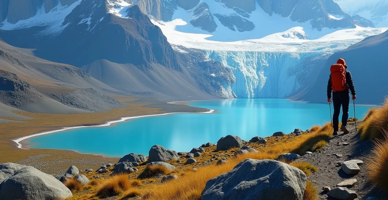
Grey glacier viewpoint: ventisquero grey trekking options
Grey Glacier represents one of the most accessible glacier viewpoints in Patagonia, offering multiple approach options ranging from easy walks to challenging ice trekking experiences. The glacier extends from the Southern Patagonian Ice Field and terminates in Grey Lake, creating dramatic calving events where massive ice chunks break away and crash into the lake below. Standard hiking approaches include the Grey Glacier Lookout trail and the more challenging trek to Grey Glacier’s eastern edge.
Advanced adventurers can participate in ice trekking excursions that involve walking directly on the glacier surface using crampons and specialized equipment. These guided experiences provide intimate access to the glacier’s crevasses, seracs, and unique ice formations while educating participants about glacial dynamics and climate change impacts. Boat excursions across Grey Lake offer alternative perspectives on the glacier’s massive calving face, complementing land-based hiking experiences.
Los glaciares national park: argentine ice field expeditions
Los Glaciares National Park encompasses Argentina’s most spectacular mountain and glacier terrain, covering over 2,800 square miles of pristine wilderness in southern Patagonia. The park contains two distinct sections: the northern sector centered around El Chaltén and Mount Fitz Roy, and the southern sector featuring the famous Perito Moreno Glacier near El Calafate. This UNESCO World Heritage site protects critical habitat for diverse wildlife while providing access to some of South America’s most challenging and rewarding hiking opportunities.
The park’s northern section, often called the “trekking capital of Argentina,” attracts serious mountaineers and hiking enthusiasts seeking access to the Fitz Roy massif and Cerro Torre group. These granite peaks, sculpted by millions of years of glacial action, present some of the world’s most technical climbing challenges while offering spectacular hiking opportunities for non-climbing adventurers. The region’s weather patterns, influenced by the Southern Patagonian Ice Field, create rapidly changing conditions that require careful planning and flexible itineraries.
Mount fitz roy circuit: cerro chaltén technical approaches
Mount Fitz Roy, known locally as Cerro Chaltén or “smoking mountain” in the Tehuelche language, stands as one of Patagonia’s most iconic peaks at 11,171 feet elevation. The mountain’s distinctive granite profile, featured prominently in Patagonia clothing company logos, attracts photographers and hikers from around the world. The complete Fitz Roy circuit encompasses multiple approach routes and base camp locations, allowing for varying levels of difficulty and commitment ranging from day hikes to multi-week expeditions.
The standard circuit approach begins in El Chaltén and follows established trails toward Laguna de los Tres, providing the closest hiking access to Fitz Roy’s base. Alternative routes include approaches via Laguna Torre and Piedras Blancas, each offering unique perspectives on the surrounding peaks and glacial features. Weather conditions around Fitz Roy change rapidly, with the mountain frequently shrouded in clouds that can persist for days, making clear-weather viewing a prized experience among visitors.
Laguna de los tres: high alpine lake access routes
Laguna de los Tres represents the quintessential Patagonian hiking experience, combining challenging terrain with spectacular alpine lake and mountain scenery. The 14-mile round-trip trek from El Chaltén climbs approximately 2,600 feet through diverse ecosystems before reaching the glacial lake situated directly beneath Fitz Roy’s north face. The final approach involves a steep, rocky scramble that tests hikers’ endurance and route-finding skills while providing increasingly dramatic views of the surrounding peaks.
The trail passes through multiple ecological zones, beginning in Patagonian steppe grasslands before entering southern beech forests and eventually emerging above treeline into alpine environments. Laguna Capri serves as a popular rest stop and alternative destination for hikers seeking shorter adventures, while the full trek to Laguna de los Tres requires early morning starts and proper preparation for changing weather conditions. The lake itself often remains partially frozen well into the hiking season, creating surreal reflections of the surrounding granite spires.
The sight of Mount Fitz Roy reflected in the pristine waters of Laguna de los Tres represents one of the most photographed and spiritually moving experiences in all of Patagonia, where the raw power of geological forces meets the delicate beauty of alpine ecosystems.
Cerro torre base camp: advanced mountaineering staging areas
Cerro Torre, standing at 10,262 feet, presents one of the world’s most challenging climbing objectives while offering exceptional hiking opportunities to its base camp areas. The mountain’s reputation for extreme weather conditions and technical climbing difficulties attracts elite mountaineers, though the approach hikes provide accessible adventures for non-climbing enthusiasts. The standard approach follows the Laguna Torre trail, leading hikers through 11 miles of varied terrain including grasslands, forests, and glacial moraines.
Base camp areas around Cerro Torre provide spectacular vantage points for observing the mountain’s distinctive ice-encrusted summit formation, created by constant exposure to fierce Patagonian winds. The trail system includes several established viewpoints and camping areas, including Mirador Maestri, which offers close-range perspectives on the mountain’s massive east face. Advanced hikers can explore glacier approach routes that provide access to the mountain’s technical climbing routes, though specialized equipment and mountaineering experience are required for these adventures.
Huemul circuit: multi-day continental ice field traverse
The Huemul Circuit stands as one of Patagonia’s most challenging and rewarding multi-day treks, offering a complete traverse around the southern end of the Southern Patagonian Ice Field. This demanding 37-mile circuit requires four to five days to complete and involves river crossings, glacier travel, and navigation through unmarked terrain that tests even experienced backpackers. The circuit provides unparalleled access to ice field viewpoints and pristine wilderness areas rarely visited by casual hikers.
Technical challenges on the Huemul Circuit include two river crossings using fixed zip lines, steep glacier approaches requiring basic mountaineering skills, and potential whiteout conditions that demand strong navigation abilities. The circuit’s highlights include Viento Pass, offering panoramic views of the Southern Patagonian Ice Field, and Tunnel Camp, situated beneath towering granite walls. This expedition-level trek requires complete self-sufficiency, proper cold-weather gear, and flexible scheduling to accommodate weather delays.
Tierra del fuego: End-of-World archipelago trails
Tierra del Fuego, literally meaning “Land of Fire,” encompasses the southernmost archipelago of South America, offering unique hiking experiences in landscapes shaped by glacial activity and maritime influences. The region’s largest island contains Tierra del Fuego National Park, Argentina’s first coastal national park, which protects diverse ecosystems ranging from Magellanic forests to alpine tundra. The park’s trail system provides access to the Beagle Channel coastline, offering perspectives on one of the world’s most historically significant waterways.
The region’s hiking opportunities range from gentle coastal walks suitable for families to challenging mountain traverses that require technical skills and cold-weather experience. Unique features include ancient beaver dams created by introduced North American beavers, subantarctic forests dominated by southern beech trees, and extensive peat bog ecosystems. The area’s location at approximately 55 degrees south latitude creates distinctive seasonal variations, with summer days extending nearly 18 hours while winter brings long periods of twilight and potential snowfall.
Coastal hiking trails in Tierra del Fuego provide opportunities to observe diverse marine wildlife including southern sea lions, Magellanic penguins, and various seabird species. The Senda Costera (Coastal Path) extends for over 5 miles along the Beagle Channel, connecting multiple bays and offering viewpoints toward the Chilean islands across the channel. Inland trails climb through lenga forests toward mountain summits that provide panoramic views of the archipelago’s complex geography, including numerous islands, channels, and fjords carved by ancient glacial action.
Perito moreno region: glacier access hiking networks
The Perito Moreno region centers around one of the world’s most accessible and dynamic glaciers, providing hiking opportunities that range from comfortable walkways to challenging ice trekking adventures. Perito Moreno Glacier, measuring approximately 97 square miles in area, represents one of the few advancing glaciers in Patagonia, creating dramatic calving events where ice chunks the size of buildings crash into Lago Argentino. The glacier’s terminus stands nearly 200 feet above the lake surface, creating an impressive wall of ancient ice accessible via well-maintained trail systems.
The standard approach involves hiking along elevated walkways and viewpoints constructed by Argentina’s national park service, providing multiple perspectives on the glacier’s massive calving face. These trails range from easy 15-minute walks to more challenging 2-hour circuits that include forest approaches and elevated lookout points. For more adventurous hikers, ice trekking excursions allow direct glacier access, where participants use crampons to explore the glacier’s surface features including crevasses, moulins, and ice formations.
Standing before Perito Moreno Glacier’s towering ice wall while listening to the thunderous sounds of calving events provides an unforgettable reminder of the dynamic forces that continue to shape Patagonia’s landscape in real-time.
Advanced hiking opportunities in the Perito Moreno area include multi-day treks to Spegazzini Glacier and Upsala Glacier, both accessible via boat transport across Lago Argentino followed by challenging overland approaches. These expeditions require proper cold-weather equipment and experience with river crossings and unmarked terrain. The region’s trail network also connects to the broader Los Glaciares National Park system, allowing for extended hiking circuits that combine glacier viewing with mountain approaches toward the Fitz Roy massif.
Northern patagonia: marble caves and carretera austral routes
Northern Patagonia encompasses diverse hiking opportunities along Chile’s famous Carretera Austral highway, a remote road system that provides access to pristine wilderness areas, glacial lakes, and unique geological formations. The region’s centerpiece includes the Marble Caves of Lago General Carrera, accessible via kayaking or boat tours, while surrounding areas offer extensive hiking networks through ancient forests and alpine environments. The Carretera Austral corridor connects multiple national parks and reserves, creating opportunities for extended hiking adventures through varied ecosystems.
Cerro Castillo National Park represents one of northern Patagonia’s premier hiking destinations, featuring the dramatic Cerro Castillo massif with its distinctive castle-like rock formations. The park’s trail system includes day hikes to glacier viewpoints and multi-day circuits around the mountain’s base, passing through diverse terrain including grasslands, forests, and alpine zones. Weather conditions in northern Patagonia tend to be more stable than in southern regions, though rainfall remains significant throughout much of the year.
Queulat National Park protects ancient temperate rainforests and hanging glaciers, offering hiking opportunities through some of South America’s most pristine woodland environments. The park’s trail network includes approaches to Queulat Hanging Glacier, forest circuits through thousand-year-old alerce trees, and challenging mountain traverses that provide access to remote glacier viewpoints. The region’s biodiversity includes endemic plant species and wildlife populations that have remained relatively unchanged for millions of years.
Pumalín Park, created through private conservation efforts, encompasses over 700,000 acres of pristine temperate rainforest and provides hiking access to some of Chile’s most remote wilderness areas. The park’s trail system ranges from gentle nature walks through ancient alerce groves to challenging volcano ascents that require technical mountaineering skills. These diverse hiking opportunities showcase northern Patagonia’s most remarkable ecosystems, from coastal fjords influenced by Pacific weather patterns to high-altitude environments shaped by volcanic activity.
Essential patagonian weather patterns and seasonal trekking windows
Understanding Patagonia’s complex weather patterns represents a crucial factor in planning successful hiking expeditions across this vast and climatically diverse region. The area’s position between the Pacific and Atlantic Oceans, combined with the influence of the Southern Patagonian Ice Field and prevailing westerly winds, creates highly variable conditions that can change dramatically within hours. The region experiences four distinct seasons, though weather patterns can vary significantly between northern and southern areas, with coastal zones displaying more moderate temperatures while inland mountain areas face extreme conditions.
The summer hiking season, extending from December through February, provides the most stable weather conditions and longest daylight hours, with some areas experiencing up to 17 hours of daylight during peak summer. However, this period also brings the highest visitor numbers and strongest winds, particularly in exposed areas around Torres del Paine and Mount Fitz Roy. Average temperatures during summer range from 50-70°F (10-21°C) in lower elevations, while mountain areas remain significantly cooler with potential for sudden temperature drops and snow at any time of year.
Autumn conditions, from March through May, offer some of the most spectacular hiking experiences in Patagonia, with fewer crowds, dramatic lighting conditions, and relatively stable weather patterns. The famous Patagonian winds tend to be less intense during this period, though precipitation increases as the region transitions toward winter. Deciduous southern beech forests display brilliant fall colors, creating exceptional photographic opportunities along many trail systems. Temperature ranges become more variable during autumn, requiring hikers to prepare for both warm sunny days and cold, wet conditions.
The legendary Patagonian winds, known locally as “viento,” can exceed 100 mph in exposed areas, creating conditions where experienced hikers must crawl on hands and knees to avoid being blown off ridges, making wind forecasting as critical as temperature and precipitation planning.
Winter hiking in Patagonia, while challenging, opens unique opportunities for snow camping, winter mountaineering, and experiencing the region’s dramatic seasonal transformation. Many high-altitude trails become inaccessible due to snow accumulation, but lower-elevation coastal areas and forest trails remain hikeable with proper cold-weather equipment. Daylight hours shrink to as few as 8 hours in mid-winter, requiring careful trip planning and early starts for longer adventures. Advanced winter hikers can access ice climbing opportunities and experience Patagonia’s pristine snow-covered landscapes without summer crowds.
Spring conditions, from September through November, present the most unpredictable weather patterns as the region emerges from winter. Snow levels fluctuate dramatically, creating hazardous avalanche conditions in mountain areas while offering excellent opportunities for observing wildlife emergence and plant growth cycles. Many trails remain partially snow-covered through October, requiring microspikes or crampons for safe travel. Spring weather systems bring frequent precipitation and rapid temperature fluctuations, making flexible itineraries and comprehensive gear preparation essential for successful hiking adventures.
Microclimate variations across Patagonia create dramatically different conditions within relatively short distances, particularly in areas where maritime influences meet continental weather patterns. The windward slopes of mountains receive significantly more precipitation than leeward areas, creating lush temperate rainforests on western exposures while eastern slopes remain relatively arid. Hikers traversing mountain passes often experience rapid transitions from mild, humid conditions to cold, dry environments within a few miles of elevation change.
Understanding regional weather patterns requires monitoring multiple forecasting sources and maintaining flexibility in hiking plans to accommodate rapidly changing conditions. Local weather stations and ranger offices provide valuable real-time information about trail conditions, avalanche risks, and severe weather warnings. Successful Patagonian hiking expeditions require comprehensive preparation for all possible weather scenarios, from blazing sun and fierce winds to sudden snowstorms and prolonged periods of rain or fog that can persist for days.