Iceland’s volcanic landscapes represent some of the most spectacular and dynamic geological formations on Earth, drawing millions of visitors annually to witness active eruptions, steaming geothermal fields, and otherworldly lava formations. The island nation sits atop the Mid-Atlantic Ridge, where tectonic plates diverge and create an environment of constant volcanic activity that has shaped the country’s dramatic terrain for millennia. With approximately 130 volcanoes and 30 active volcanic systems, Iceland offers unparalleled opportunities for volcanic tourism, from accessible lava tube explorations to challenging summit climbs on active stratovolcanoes.
However, the very forces that create Iceland’s breathtaking volcanic scenery also present significant safety challenges for travelers. Volcanic gases, unstable terrain, rapidly changing weather conditions, and the unpredictable nature of volcanic activity require careful planning, proper equipment, and thorough understanding of safety protocols. The country’s sophisticated monitoring systems, professional guide services, and established safety infrastructure make it possible for visitors to experience these geological wonders while minimizing risks through informed decision-making and appropriate precautions.
Understanding iceland’s active volcanic systems and risk assessment protocols
Iceland’s volcanic landscape operates within a complex network of interconnected systems that require continuous monitoring and assessment to ensure visitor safety. The country’s geological activity stems from its unique position on both the Mid-Atlantic Ridge and above a mantle hotspot, creating conditions where volcanic eruptions occur approximately every four to five years. Understanding these systems and their associated risks forms the foundation for safe volcanic tourism in Iceland.
Reykjanes peninsula volcanic activity monitoring and alert systems
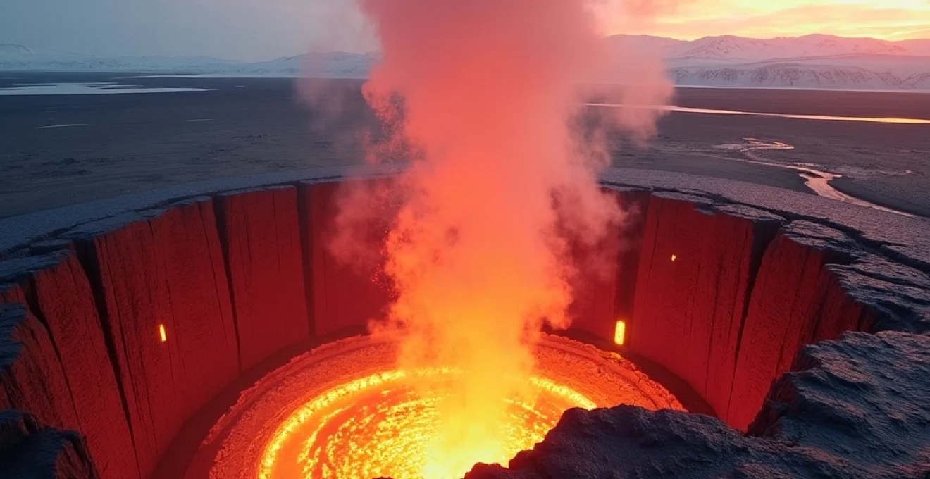
The Reykjanes Peninsula has experienced unprecedented volcanic activity since 2021, with multiple eruptions at Fagradalsfjall and the Sundhnúkagígar crater row series transforming the region into a dynamic volcanic laboratory. The Icelandic Met Office operates an extensive network of seismographs, GPS stations, and gas sensors throughout the peninsula to track magma movement, ground deformation, and volcanic gas emissions. These monitoring systems provide real-time data that enables authorities to issue color-coded alert levels ranging from green (no immediate threat) to red (major eruption imminent or in progress).
Travelers planning to visit the Reykjanes Peninsula should understand that volcanic activity in this region follows distinct patterns of earthquake swarms, ground uplift, and gas emissions that typically precede eruptions by days or weeks. The monitoring infrastructure includes automated alert systems that notify emergency services, tour operators, and the public when conditions change. However, visitors must recognize that volcanic eruptions can still occur with minimal warning , requiring constant vigilance and adherence to official evacuation orders when issued.
Vatnajökull national park subglacial eruption hazard classifications
Vatnajökull National Park encompasses several of Iceland’s most powerful volcanic systems, including Grímsvötn, Bárðarbunga, and Öræfajökull, all of which lie beneath massive ice caps that create unique hazard profiles. Subglacial eruptions in this region can generate catastrophic glacial floods known as jökulhlaups, which have historically caused widespread destruction across southern Iceland. The park’s hazard classification system categorizes risks based on eruption magnitude, ice thickness, and potential flood pathways to populated areas.
The Vatnajökull region’s monitoring network includes ice-penetrating radar systems, thermal sensors, and hydrological monitoring stations that track changes in ice thickness, meltwater production, and river flow rates. These systems enable scientists to model potential flood scenarios and establish evacuation zones well in advance of expected events. Visitors to the region must understand that access restrictions can change rapidly based on volcanic and glacial conditions, with some areas remaining completely off-limits during periods of heightened activity.
Eyjafjallajökull and katla volcanic complex safety protocols
The Eyjafjallajökull-Katla volcanic complex represents one of Iceland’s most closely monitored systems due to its history of explosive eruptions and potential for widespread ash production. The 2010 Eyjafjallajökull eruption demonstrated how relatively modest volcanic events can have global impacts through ash cloud formation, while Katla’s historical eruptions have generated some of the largest jökulhlaups on record. Safety protocols for this region emphasize early detection of magma intrusion, ash dispersal modeling, and coordinated response planning with international aviation authorities.
The monitoring infrastructure around these volcanoes includes specialized equipment for detecting ash production, gas composition analysis, and real-time ash cloud tracking through satellite imagery and ground-based sensors. Emergency response protocols involve multiple agencies coordinating evacuation procedures, airspace closures, and public health measures related to ash exposure. Travelers in the region during periods of unrest should maintain awareness of wind patterns that could affect ash dispersal and ensure they have access to reliable communication channels for receiving emergency updates.
Real-time seismic data interpretation from IMO weather service
The Icelandic Meteorological Office (IMO) serves as the primary source for volcanic hazard information, operating a comprehensive network of monitoring stations that provide continuous seismic data, gas measurements, and ground deformation readings. The organization’s real-time data interpretation capabilities enable rapid assessment of changing volcanic conditions and distribution of critical safety information to emergency responders and the public. Understanding how to access and interpret IMO data becomes essential for travelers planning independent visits to volcanic areas.
The IMO website provides detailed volcanic status updates, seismic activity maps, and hazard assessments that travelers can use to make informed decisions about volcanic tourism activities. The service includes mobile applications that deliver push notifications for significant seismic events or changes in volcanic alert levels. However, visitors should recognize that seismic data interpretation requires expertise , and consultation with professional guides or tour operators remains advisable for accurate risk assessment in dynamic volcanic environments.
Essential volcanic terrain navigation equipment and safety gear
Exploring Iceland’s volcanic landscapes requires specialized equipment designed to handle the unique challenges of volcanic terrain, including sharp lava rocks, unstable surfaces, extreme temperatures, and potentially dangerous gas emissions. The harsh environmental conditions found in volcanic areas demand high-quality gear that can withstand abrasive surfaces, temperature extremes, and corrosive volcanic gases while providing reliable protection for travelers venturing into these extraordinary but hazardous environments.
Gas detection devices for hydrogen sulfide and carbon dioxide monitoring
Volcanic areas in Iceland frequently emit dangerous gases including hydrogen sulfide, carbon dioxide, and sulfur dioxide, which can accumulate in low-lying areas and pose serious health risks to travelers. Professional-grade gas detection devices capable of monitoring multiple gas types simultaneously have become essential equipment for serious volcanic exploration. These devices typically feature audible and visual alarms that activate when gas concentrations reach dangerous levels, providing critical early warning for travelers to evacuate affected areas.
Modern multi-gas detectors designed for volcanic environments can simultaneously monitor carbon monoxide, hydrogen sulfide, sulfur dioxide, and oxygen levels while maintaining accuracy in the extreme temperature variations common in geothermal areas. Battery life, calibration requirements, and durability in corrosive environments represent key considerations when selecting gas monitoring equipment. Travelers should understand that gas concentrations can change rapidly with wind conditions , making continuous monitoring essential rather than periodic spot checks in potentially hazardous areas.
Specialized volcanic rock trekking boots and crampons selection
Iceland’s volcanic terrain presents unique challenges for footwear, with sharp lava rock, loose scree, and ice-covered volcanic surfaces requiring specialized trekking boots designed for extreme abrasion resistance and superior grip. Volcanic rock formations create particularly demanding conditions that can quickly destroy standard hiking boots, while icy conditions near glacial volcanoes require additional traction devices. High-quality volcanic terrain boots typically feature reinforced toe and heel areas, thick rubber soles with aggressive tread patterns, and materials resistant to volcanic ash and corrosive gases.
Crampon selection for volcanic terrain differs significantly from standard ice climbing applications, requiring models that can handle mixed conditions of ice, rock, and loose volcanic material. Flexible crampons with replaceable points work better than rigid models when transitioning between different surface types common in volcanic environments. Boot and crampon compatibility becomes critical, as mismatched systems can create dangerous situations in challenging volcanic terrain where secure footing means the difference between safe exploration and serious injury.
Emergency communication systems in remote lava field environments
Remote volcanic areas in Iceland often lack reliable cellular coverage, making emergency communication systems essential safety equipment for travelers venturing into isolated lava fields and volcanic highlands. Satellite communication devices, including personal locator beacons (PLBs) and satellite messengers, provide critical capabilities for summoning rescue services when standard communication methods fail. These systems operate independently of terrestrial infrastructure and can function even in challenging volcanic environments where radio signals may be blocked by terrain features.
Modern satellite communication devices offer various features including GPS tracking, two-way messaging, and emergency beacon activation that can significantly improve rescue response times in remote volcanic areas. Battery life, signal reliability, and ease of operation under stress represent crucial factors when selecting emergency communication equipment. Understanding device limitations, such as signal acquisition times and geographic coverage areas, helps travelers develop realistic emergency response plans that account for the unique challenges of volcanic terrain exploration.
Thermal protection clothing for active geothermal zone exploration
Active geothermal areas and recent lava flows create extreme temperature variations that require specialized thermal protection clothing to prevent burns and heat-related injuries. Professional volcanic exploration clothing systems typically include multiple layers designed to handle temperature extremes while providing mobility and breathability necessary for active exploration. Heat-resistant outer shells, insulating mid-layers, and moisture-wicking base layers work together to create comprehensive thermal protection systems suitable for geothermal environments.
Specialized materials including aramid fibers, aluminized fabrics, and high-temperature-resistant synthetics provide protection against radiant heat from lava flows and steam vents while maintaining durability in abrasive volcanic environments. Clothing system design must balance thermal protection with practical considerations such as mobility, ventilation, and layering flexibility to accommodate changing conditions during extended volcanic exploration activities. Proper thermal protection extends beyond clothing to include heat-resistant gloves, face protection, and eye protection designed for high-temperature environments.
Professional guided tour operators and certified volcanic expedition services
Professional guided tour operators specializing in volcanic exploration provide essential expertise, safety equipment, and local knowledge that significantly enhance both safety and educational value for travelers visiting Iceland’s volcanic landscapes. These operators maintain current certifications, insurance coverage, and specialized training in volcanic hazard recognition, emergency response procedures, and geological interpretation that individual travelers cannot easily replicate. The complex and rapidly changing nature of volcanic environments makes professional guidance particularly valuable for accessing active volcanic areas safely while maximizing the educational and experiential benefits of volcanic tourism.
Certified volcanic expedition services operate under strict safety protocols developed through years of experience in dynamic volcanic environments, incorporating real-time hazard assessment, group management techniques, and emergency response capabilities tailored specifically to volcanic terrain challenges. These operators maintain relationships with monitoring agencies, emergency services, and local authorities that provide access to current safety information and rapid response capabilities unavailable to independent travelers. Professional guides possess specialized knowledge of volcanic processes, hazard recognition, and risk mitigation strategies that enable safe access to spectacular volcanic phenomena while providing comprehensive educational interpretation of geological processes.
The selection process for volcanic tour operators should emphasize safety credentials, guide qualifications, equipment standards, and emergency response capabilities rather than focusing solely on cost or itinerary appeal. Reputable operators provide detailed safety briefings, high-quality protective equipment, and clear communication about risk factors and safety procedures before beginning volcanic exploration activities. Professional volcanic guides undergo continuous training in hazard assessment, first aid, and emergency evacuation procedures specific to volcanic environments, ensuring they can respond effectively to changing conditions or emergency situations during expeditions.
Quality volcanic tour operators maintain current insurance coverage, emergency communication systems, and established relationships with rescue services that provide additional safety layers for their clients. These operators also contribute valuable data to volcanic monitoring efforts through their regular observation activities and maintain communication protocols with scientific monitoring agencies to ensure they receive current hazard assessments and safety recommendations for their operational areas.
Specific volcanic destination safety protocols and access restrictions
Each of Iceland’s major volcanic destinations presents unique safety challenges and access requirements that travelers must understand before planning visits to these spectacular but potentially hazardous locations. The diversity of volcanic environments across Iceland means that safety protocols, equipment requirements, and access restrictions vary significantly between different sites, from easily accessible geothermal areas to challenging high-altitude volcanic summits. Understanding destination-specific requirements enables travelers to prepare appropriately and make informed decisions about their volcanic tourism activities.
Landmannalaugar rhyolite mountain range trail safety measures
Landmannalaugar’s colorful rhyolite mountains and extensive geothermal activity create a unique environment where trail safety measures must address both volcanic hazards and alpine climbing challenges. The region’s high elevation, variable weather conditions, and active geothermal features require travelers to prepare for rapid temperature changes, unstable trail conditions, and potential exposure to volcanic gases in geothermal areas. Trail marking systems in Landmannalaugar use specialized posts designed to remain visible during harsh weather conditions, but travelers must understand that visibility can change rapidly due to weather and volcanic steam.
Geothermal safety protocols in Landmannalaugar emphasize maintaining safe distances from hot springs, steam vents, and mud pots where surface crusts may be unstable and water temperatures can exceed 80°C. The region’s trail system includes designated crossing points for geothermal streams and established camping areas positioned away from active geothermal features. Emergency shelters and communication points are strategically located throughout the trail network, but travelers should carry comprehensive emergency equipment and maintain awareness of evacuation routes to these facilities.
Askja caldera and víti crater lake access regulations
Askja Caldera’s remote location in Iceland’s central highlands requires extensive preparation and adherence to strict access regulations designed to protect both visitor safety and the fragile volcanic environment. The caldera’s access routes traverse challenging highland terrain where weather conditions can change rapidly and vehicle breakdowns can create serious emergency situations. Access regulations typically restrict travel to specific months when road conditions permit safe passage, with mandatory registration systems that track visitor movements and enable search and rescue operations when necessary.
The Víti crater lake presents specific safety challenges due to unstable crater rim conditions, steep slopes, and potential for rockfall from recent volcanic activity. Safety protocols prohibit swimming in the crater lake due to unpredictable water chemistry and temperature variations, while viewing areas are restricted to designated paths with stable footing. Emergency response capabilities in the Askja region are limited by remote location and challenging terrain, making self-sufficiency in emergency situations essential for visitors to this spectacular but isolated volcanic destination.
Westman islands eldfell volcano climbing restrictions
Eldfell volcano on Heimaey island presents unique safety challenges related to recent volcanic activity, unstable volcanic slopes, and proximity to populated areas that require specific climbing restrictions and safety protocols. The volcano’s 1973 eruption created loose volcanic material and unstable slopes that continue to present hazards for climbers, while residual heat in some areas of the volcanic cone can create dangerous conditions for unprepared visitors. Climbing restrictions typically prohibit access during high wind conditions when loose volcanic material becomes a significant hazard, and require specialized equipment for safe ascent of unstable volcanic slopes.
Safety protocols for Eldfell climbing emphasize route selection on stable surfaces, group travel procedures for mutual safety monitoring, and emergency descent routes that avoid areas of loose volcanic material. The volcano’s proximity to Heimaey town means that rescue services are relatively accessible compared to remote highland volcanoes, but climbers must still carry comprehensive safety equipment and maintain communication capabilities throughout their ascent. Weather conditions can change rapidly on Eldfell due to its coastal location, requiring continuous monitoring and willingness to abort climbs when conditions become unsafe.
Hekla volcano summit approach route safety guidelines
Hekla volcano’s reputation as one of Iceland’s most active and unpredictable volcanoes requires stringent safety guidelines for summit approach routes that emphasize early detection of volcanic unrest and rapid evacuation capabilities. The volcano’s history of eruptions with minimal warning periods means that climbers must maintain constant awareness of seismic activity, gas emissions, and other precursory signs of volcanic unrest. Summit approach routes are subject to immediate closure when monitoring systems detect increased volcanic activity, with mandatory evacuation procedures that prioritize speed over equipment recovery.
Safety guidelines for Hekla climbing require comprehensive emergency equipment including gas masks, emergency shelters, and satellite communication devices capable of functioning in the electromagnetic environments created by volcanic activity. Route planning must include multiple descent options and emergency rally points where climbers can regroup during evacuation procedures. The volcano’s steep slopes and loose volcanic material create additional hazards that require specialized mountaineering techniques and equipment designed for volcanic terrain conditions.
Emergency response procedures and evacuation routes planning
Effective emergency response procedures for volcanic tourism in Iceland require comprehensive planning that addresses the unique challenges of volcanic environments, including rapidly changing conditions, remote locations, and potential communication difficulties. Emergency response planning must consider multiple scenario types ranging from individual medical emergencies to large-scale
volcanic evacuations that may affect multiple tourist groups simultaneously. The development of comprehensive emergency response procedures requires understanding of local rescue capabilities, communication systems, and evacuation infrastructure available in different volcanic regions across Iceland.Emergency response procedures must account for the unique characteristics of volcanic hazards including rapid onset times, multiple simultaneous threats, and potential communication disruptions caused by electromagnetic interference from volcanic activity. Professional volcanic tour operators maintain detailed emergency action plans that specify response procedures for different threat levels, evacuation routes, rally points, and communication protocols with rescue services. These plans require regular updates based on changing volcanic conditions, infrastructure modifications, and lessons learned from actual emergency responses.
The coordination of emergency response efforts involves multiple agencies including the Icelandic Coast Guard, National Commissioner of Police, emergency medical services, and local search and rescue teams, each with specific roles and capabilities in volcanic emergency situations. Communication protocols between these agencies ensure rapid information sharing and coordinated response efforts when volcanic emergencies develop. Emergency response procedures also include provisions for international coordination when volcanic events affect air travel or require specialized rescue capabilities not available within Iceland.
Personal emergency response planning for volcanic tourism requires travelers to understand their responsibilities within the broader emergency response system while maintaining capabilities for self-rescue in situations where external assistance may be delayed. This includes carrying appropriate emergency equipment, maintaining communication capabilities, understanding evacuation routes, and possessing basic first aid skills relevant to volcanic hazard injuries. Emergency response training for volcanic environments should include recognition of volcanic hazard warning signs, emergency signaling techniques, and group management procedures during evacuation scenarios.
Evacuation route planning requires detailed knowledge of terrain features, infrastructure limitations, and alternative pathway options that remain accessible during different types of volcanic emergencies. Primary evacuation routes from popular volcanic destinations are regularly maintained and marked, but travelers must understand that volcanic events can rapidly alter terrain conditions and block established pathways. Secondary and tertiary evacuation routes provide backup options when primary routes become impassable, requiring travelers to possess navigation skills and emergency equipment suitable for potentially challenging terrain conditions.
The effectiveness of evacuation procedures depends heavily on advance planning, regular practice, and clear communication protocols between tour leaders, group members, and emergency services. Professional volcanic tour operators conduct regular evacuation drills and maintain current information about route conditions, shelter locations, and communication capabilities along evacuation pathways. Evacuation success often depends on early initiation of procedures before conditions become critical, emphasizing the importance of conservative decision-making and proactive response to changing volcanic conditions.
Weather conditions impact on volcanic landscape accessibility and safety
Weather conditions play a crucial role in determining both the accessibility and safety of Iceland’s volcanic landscapes, with rapidly changing meteorological conditions capable of transforming routine volcanic tourism activities into dangerous situations requiring immediate response. Iceland’s sub-Arctic climate creates weather patterns characterized by sudden changes, extreme temperature variations, and severe wind conditions that interact with volcanic terrain to create unique hazard combinations not found in other environments. Understanding these weather-related risks becomes essential for safe volcanic exploration planning.
Wind conditions significantly impact volcanic tourism safety through their effects on volcanic gas dispersal, temperature perception, and stability on exposed volcanic terrain. High winds can rapidly disperse protective clothing layers while simultaneously concentrating dangerous volcanic gases in sheltered areas where travelers might seek protection from wind exposure. Wind speed and direction also affect volcanic ash dispersal patterns during active eruptions, potentially creating visibility hazards and respiratory risks in areas that would otherwise remain safe during calm conditions.
Temperature extremes common in volcanic environments can create hypothermia risks even during summer months, particularly when combined with wind exposure and wet conditions from volcanic steam or precipitation. Geothermal areas create localized temperature variations that can reach extreme values within short distances, requiring travelers to rapidly adjust their thermal protection systems while navigating challenging terrain. Temperature gradients near active volcanic features can create dangerous thermal shock conditions when moving between hot and cold environments without appropriate transition periods.
Precipitation in volcanic areas presents unique challenges beyond standard hiking concerns, with rain and snow creating slippery conditions on smooth volcanic rock surfaces while potentially triggering rockfall from unstable volcanic slopes. Wet conditions also increase the risk of hypothermia and reduce the effectiveness of emergency signaling devices and communication equipment. Volcanic terrain drainage patterns can concentrate precipitation into flash flood conditions in low-lying areas, creating sudden hazards in locations that appear safe during dry conditions.
Visibility conditions in volcanic areas can deteriorate rapidly due to combinations of weather phenomena and volcanic activity, including fog formation around geothermal features, blowing volcanic dust, and steam plume interactions with atmospheric moisture. Low visibility conditions make navigation extremely challenging in volcanic terrain where trails may be poorly defined and terrain features can appear similar across large areas. Emergency response becomes significantly more difficult when visibility conditions prevent effective communication with rescue services or identification of evacuation routes.
Seasonal variations in weather patterns affect volcanic tourism accessibility through their impact on road conditions, daylight hours, and emergency service availability in remote areas. Winter conditions may make some volcanic destinations completely inaccessible while creating additional hazards such as hidden crevasses, ice-covered volcanic features, and extended exposure periods due to shortened daylight hours. Summer weather patterns can bring different challenges including sudden storms, temperature extremes, and increased tourist activity that may complicate emergency response efforts.
Weather monitoring and forecasting for volcanic tourism requires understanding of both regional weather patterns and localized conditions created by volcanic activity and terrain features. Professional weather services provide specialized forecasts for volcanic areas that account for elevation effects, geothermal influences, and terrain-specific weather phenomena not captured in standard forecasts. Microclimate variations around volcanic features can create conditions significantly different from regional forecasts, requiring continuous local weather assessment during volcanic exploration activities.
The integration of weather information into volcanic tourism safety planning requires understanding how different weather conditions affect specific volcanic hazards and emergency response capabilities. This includes recognizing weather patterns that increase volcanic gas accumulation risks, create unstable terrain conditions, or limit emergency evacuation options. Advanced weather planning for volcanic tourism involves monitoring extended forecasts, understanding seasonal patterns, and maintaining flexibility in itinerary planning to accommodate changing weather conditions that may affect safety or accessibility of planned volcanic destinations.